 Parks & Legends
Zion National Park Itinerary: 3 Days With Shuttle Map

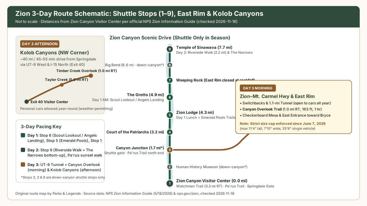
This 3-day Zion National Park itinerary sequences your days around Zion’s real-world bottlenecks: limited Visitor Center parking, shuttle-only canyon rules, and permit or river-flow closures on Angels Landing and The Narrows (last checked: 2026-11-17). Instead of crisscrossing the canyon, you spend Day 1 on the mid-canyon cliffs (Stops 5 & 6), Day 2 in the Virgin River slot corridor (Stop 9), and Day 3 driving the East Rim tunnel and quiet Kolob Canyons.
Editorial safety note: This itinerary is a planning framework, not guided instruction. Desert heat, cliff drop-offs, and sudden flash floods carry serious risk; check live alerts at the Visitor Center and follow all rules in the NPS Zion Information Guide.
Where Zion sits on the map
Nearby national parks
Distances are straight lines between the park points listed by the National Park Service (as the crow flies). Drive times, when shown, are estimates from OpenStreetMap routing with no traffic, snow or closures: check roads and seasonal closures with the park before you go.
- Bryce Canyon Utahabout 50 mi (81 km) as the crow flies; ≈ 110 road mi.
- Grand Canyon Arizonaabout 103 mi (165 km) as the crow flies; ≈ 273 road mi.
- Capitol Reef Utahabout 119 mi (191 km) as the crow flies; ≈ 218 road mi.
- Great Basin Nevadaabout 132 mi (213 km) as the crow flies; ≈ 197 road mi.
- Canyonlands Utahabout 184 mi (296 km) as the crow flies.
Locations: NPS park data, checked 2026-11-17. See the full map of all 64 parks.
Before you go: fees, passes, permits, and shuttle hours
Lock down four details before your trip (last checked: 2026-11-17):
- Entrance fee & $100 nonresident surcharge: Standard 7-day entry is $35/vehicle ($30/motorcycle, $20/person; NPS Zion Fees). Because Zion is one of the 11 nonresident-fee parks, non-U.S. residents age 16+ owe an extra $100/person unless covered by the $250 Non-Resident Annual Pass (NPS Nonresident Fees). Compare rates in National Park Entrance Fees and our America the Beautiful Pass Calculator.
- Free shuttle & seasonal hours (no ticket needed): Private cars cannot drive Zion Canyon Scenic Drive during shuttle season (NPS Shuttle System). Shuttles are free, arrive every 5–10 minutes, and take ~45 minutes one way to Stop #9. In fall 2026, the Sept 13–Oct 24 window (7:00 a.m.–6:00 p.m., last bus from Stop 9 at 7:15 p.m.) has already ended; on the remaining 2026 schedule, the Zion Canyon Line runs 7:00 a.m.–5:00 p.m. through Nov 28 (last bus from Stop 9 at 6:15 p.m.), pauses Nov 29–Dec 25, and runs 8:00 a.m.–4:30 p.m. for Dec 26–Jan 2 (2027 shuttle dates are not yet published on the NPS Shuttle System page).
- Angels Landing permit & tunnel size rule: Hiking the chained section past Scout Lookout requires a Recreation.gov lottery permit year-round ($6 application for up to 6 people + $3/person fee; NPS Angels Landing Permits). Track deadlines in National Park Timed Entry Reservations. Also note that starting June 7, 2026, one-way oversize tunnel escorts ended on the Zion–Mt. Carmel Highway. Vehicles exceeding 11 ft 4 in tall, 7 ft 10 in wide, or 35 ft 9 in long must detour around the park (NPS Zion Info Guide).
- Best month & gear: October–early November and late April bring mild canyon highs, whereas spring snowmelt (>150 CFS) often closes The Narrows. Compare all 12 months in Best Time to Visit Zion National Park and pack layers from our National Park Packing List.
For a short, official look at how the two Zion shuttle routes work (where to board, parking, stops and rules), the park published this video in October 2024. Schedules change, so confirm dates on the NPS shuttle page.

Day 1: West Rim, Scout Lookout (or Angels Landing), and Emerald Pools
- Early Morning (7:00–11:00 a.m.) — Stop #6 The Grotto: Park early at the Zion Canyon Visitor Center or enter on foot from Springdale via the free Springdale Line, then ride the canyon shuttle 4.9 miles north to Stop #6 (The Grotto). Hike the paved switchbacks and Walter’s Wiggles up the West Rim Trail to Scout Lookout (4.2 mi round trip, 1,000 ft elevation change, ~3 hours per NPS Zion Info Guide; no permit required to Scout Lookout). With an Angels Landing permit, continue along the chained spine—making the full Angels Landing hike 5.4 miles round trip with 1,488 ft of elevation gain (~4 hours) per NPS Angels Landing Permits.
- Midday & Lunch (11:30 a.m.–1:30 p.m.) — Stop #5 Zion Lodge: Walk the flat Grotto Trail (1.0 mi RT, 35 ft; 0.5 mi one way) or ride one shuttle stop south to Stop #5 (Zion Lodge). Refill water bottles and eat lunch on the shaded lawn (
1 gallon per person per dayrecommended in heat per NPS Zion Info Guide). - Afternoon (1:30–4:00 p.m.) — Emerald Pools: From Stop #5, hike the Lower Emerald Pool Trail (1.2 mi RT, 150 ft) and add the Middle Emerald Pools (2.2 mi RT, 150 ft) or sandy Upper Emerald Pool spur (+1.0 mi RT, 200 ft) beneath sheer cliffs (no swimming allowed).
- Late Afternoon / Sunset — Stop #1 Visitor Center: Rest before hiking the Watchman Trail (3.3 mi RT, 368 ft, ~2 hours) from Stop #1 for sunset views across Springdale.
Day 2: Temple of Sinawava, The Narrows, and Pa’rus Trail
- Morning Anchor (7:00 a.m.–1:00 p.m.) — Stop #9 Temple of Sinawava: Ride an early shuttle 7.7 miles to Stop #9. Follow paved Riverside Walk (2.2 mi RT / ~1 mi one way, 57 ft) to the end of the concrete path, where the Virgin River becomes the trail. Hike bottom-up into The Narrows (no permit required upstream as far as Big Spring). The NPS Narrows guide describes the full Big Spring out-and-back from the river mouth as “a strenuous, ten-mile round trip, all-day adventure”, while the NPS Zion Info Guide lists the river section at 9.4 mi (15.1 km) round trip, 334 ft gain, up to 8 hours; turning back after 2–3 hours still captures the narrowest 20-to-30-foot walls. Wear closed-toed boots and bring a sturdy walking stick.
- Plan B if The Narrows is closed (>150 CFS spring runoff or Flash Flood Warning): Never enter narrow canyons when storms threaten. The Narrows closes whenever river flow exceeds 150 CFS or a Flash Flood Warning is issued (remaining closed at least two hours after a warning lifts; NPS The Narrows). Instead, walk Riverside Walk, ride to Stop #6 for Kayenta Trail (2.0 mi RT, 150 ft), view Stop #4 (Court of the Patriarchs), and visit the Zion Human History Museum (Stop #2).
- Midday Reset (1:30–4:00 p.m.): Head back to Springdale during peak afternoon heat for lunch and dry footwear.
- Evening (4:30 p.m.–Sunset): Walk or bike the paved Pa’rus Trail (3.5 mi RT, 50 ft) between the Visitor Center and Canyon Junction. It is the only trail in Zion open to bicycles and leashed pets (NPS Zion Info Guide).
Day 3: Zion–Mount Carmel Tunnel, Canyon Overlook, and Kolob Canyons
Day 3 uses your own car on two paved corridors where park shuttles do not run:
- Morning (7:30–11:00 a.m.) — Zion–Mount Carmel Highway (UT-9) & Canyon Overlook: Drive up the switchbacks from Canyon Junction through the Zion–Mount Carmel Tunnel. Right outside the east portal, park in one of the small roadside spaces for the Canyon Overlook Trail (1.0 mi RT, 163 ft, ~1 hour), then continue east to Checkerboard Mesa (NPS Zion Info Guide). (Important closure note: due to rockfall at Weeping Rock, the East Rim Trail is closed from Zion Canyon; hikers heading to Observation Point via East Mesa Trail—6.8 miles round trip—must drive outside the east boundary on unpaved dirt roads that require high-clearance or 4-wheel-drive vehicles and are often impassable when wet or snowy per NPS East Rim Trails.)
- Midday (11:30 a.m.–1:30 p.m.): Return west on UT-9 and head north on I-15 to Exit 40 for lunch along the way.
- Afternoon (1:30–5:30 p.m.) — Kolob Canyons District: Enter Zion’s quiet northwest corner at Exit 40 along the 5-mile Kolob Canyons Road. Hike Taylor Creek Trail (5.0 mi RT, 450 ft, ~3.5 hours, Wilderness group limit 12) past two historic log cabins to Double Arch Alcove, and catch sunset along Timber Creek Overlook Trail (1.0 mi RT, 100 ft, 1 hour) (NPS Kolob Canyons Trails; NPS Zion Info Guide).
Zion hikes by difficulty (official NPS stats)
Every row below cites a single official NPS source without mixing figures (last checked: 2026-11-17)—the trail table in the NPS Zion Information Guide (PDF, published 5/18/2026), plus NPS Angels Landing Permits for full Angels Landing stats:
| Trail | Access / Stop | Difficulty | Round-Trip Distance | Elevation Change | Avg. Time | Permit / Key Rule |
|---|---|---|---|---|---|---|
| Pa’rus Trail | Stop #1 (Visitor Ctr) | Easy | 3.5 mi (5.6 km) | 50 ft (15 m) | 2 hr | No permit · Paved; bikes & leashed pets OK |
| Lower Emerald Pool | Stop #5 (Zion Lodge) | Easy | 1.2 mi (1.9 km) | 150 ft (46 m) | 1 hr | No permit · No swimming; icy in winter |
| Riverside Walk | Stop #9 (Sinawava) | Easy | 2.2 mi (3.5 km) | 57 ft (17 m) | 1.5 hr | No permit · Paved path to Narrows start |
| Timber Creek Overlook | Kolob Canyons Rd | Easy/Mod | 1.0 mi (1.6 km) | 100 ft (30 m) | 1 hr | No permit · Ridge views; no pets |
| Canyon Overlook | East of UT-9 Tunnel | Moderate | 1.0 mi (1.6 km) | 163 ft (50 m) | 1 hr | No permit · Drop-offs; very limited parking |
| Kayenta Trail | Stop #6 (The Grotto) | Moderate | 2.0 mi (3.2 km) | 150 ft (46 m) | 1.5 hr | No permit · Links Grotto to Emerald Pools |
| Watchman Trail | Stop #1 (Visitor Ctr) | Moderate | 3.3 mi (5.3 km) | 368 ft (112 m) | 2 hr | No permit · Exposed afternoon sun |
| Taylor Creek Trail | Kolob Canyons Rd | Moderate | 5.0 mi (8.0 km) | 450 ft (137 m) | 3.5 hr | No permit · Max 12 people per Wilderness group |
| Scout Lookout (West Rim) | Stop #6 (The Grotto) | Strenuous | 4.2 mi | 1,000 ft (305 m) | 3 hr | No permit to Scout Lookout (Info Guide) |
| Angels Landing (full RT) | Stop #6 (The Grotto) | Strenuous | 5.4 mi | 1,488 ft | ~4 hr | Permit required year-round (NPS Permits) |
| The Narrows (bottom-up) | Stop #9 (via Riverside) | Strenuous | 9.4 mi (15.1 km) | 334 ft (102 m) | Up to 8 hr | No permit to Big Spring · Closes >150 CFS |
Where to stay in and near Zion
Picking the right base simplifies morning shuttle boarding:
- Inside the park: Zion Lodge (Stop #5) and Watchman / South Campgrounds at Stop #1 (reservations via Recreation.gov).
- Springdale: Connected directly to the pedestrian gate via the free Springdale Line Shuttle (9 stops in town; NPS Shuttle System).
- Gateway towns farther out (Virgin, La Verkin, Hurricane, or east toward Mount Carmel/Kanab): Lower nightly rates, though you must factor in morning drive and parking time. Compare areas in Where to Stay Near Zion National Park.
If you have 2 days or 4 days
- 2-day version: Keep Day 1 (Scout Lookout/Angels Landing + Emerald Pools) and Day 2 morning (The Narrows bottom-up), then drive the Zion–Mount Carmel Tunnel + Canyon Overlook Trail on Day 2 late afternoon (skipping Kolob Canyons).
- 4-day version: Add a high-plateau hike to Observation Point via East Mesa Trail (6.8 miles RT; high-clearance/4WD dirt access required per NPS East Rim Trails) or explore nearby state parks.
Print this itinerary
Mobile phone service is unreliable inside Zion Canyon and at the Angels Landing permit checkpoint (NPS Angels Landing Permits). Open our free 3-Page Printable National Park Trip Planner Kit (full overview at National Park Trip Planner Printable) to log your shuttle targets, permit confirmation, and Narrows backup plan on paper.
Pair Zion with nearby Utah parks
Exiting Zion’s East Entrance on UT-9 connects straight to US-89 North toward Bryce Canyon National Park and Scenic Byway 12:
- Deciding how to split vacation days between the two? Read Zion vs. Bryce Canyon: Side-by-Side Verdict.
- Continuing across Capitol Reef, Canyonlands, and Arches? Follow our Utah Mighty 5 7-Day Road Trip.
Sources
- https://www.nps.gov/zion/planyourvisit/upload/Zion-InfoGuide.pdf
- https://www.nps.gov/zion/planyourvisit/zion-canyon-shuttle-system.htm
- https://www.nps.gov/zion/planyourvisit/angels-landing-hiking-permits.htm
- https://www.nps.gov/zion/planyourvisit/thenarrows.htm
- https://www.nps.gov/zion/planyourvisit/east-rim-wilderness-trail-descriptions.htm
- https://www.nps.gov/zion/planyourvisit/kolob-canyons-wilderness-hiking-trails.htm
- https://www.nps.gov/zion/planyourvisit/fees.htm
- https://www.nps.gov/aboutus/nonresident-fees.htm
- https://www.recreation.gov


